The Dundonnell and Fisherfield Hills: Ruadh Stac Mor (276) and A' Mhaighdean (187)
Walk date: 16/06/08
My Munro #'s: 146 and 147
Pronunciations - translations - heights:
Roo-a stak more - big red peak - 918m
Oh, it is a very long way:


We justifiably referred to this day out as 'the big one'. No matter your approach to this remote pair of hills, you're looking at in excess of 40km. There are various possibilities with Poolewe and a 4km cycleable start being one of them, but my mapping software had given this Dundonnell House start as being a mere 35km day. It was a fine example of the underestimates that are possible in the digital world; the hills are a lot simpler when flat on your home computer screen! Although in actual fact it made little difference and this proved to be a fine route in.
My Munro #'s: 146 and 147
Pronunciations - translations - heights:
Roo-a stak more - big red peak - 918m
Ah-vatyin - the maiden - 967m
Statistics:
Duration - 09:00 - 20:45
Distance - 43.1 km
Total ascent - 1942m
Weather - Broken cloud with some good sun for first half of day, but this changed to rain/heavy cloud at Ruadh Stac Mor. Still got views from both summits but remainder of day was very wet.
Team - with Paul.
Other hikers: 1 at the start who was actually off to do An Teallach, 3 soon after who had stayed overnight in Shenavail bothy, and then 3 from afar from Ruadh Stac Mor.
Oh, it is a very long way:


Paul P and George Ullapool Hills 2008 - Day 3 (Mon)
Starting at 9am, we set off on a steady pace up a good forestry track. Back home, I had wondered if this track was cycleable but it would require a good bike and good cycling legs to match as the incline is not to be sniffed at and the ground quite rocky. It would be fun on the way down however!
As the forest ends the path levels out briefly where a small bridge is crossed, but it soon rises once more until the 400m plateau of Dundonnell Forest is reached. A cairn marks the branch off the main track toward Shenavail (we actually missed this due to some fellow hikers sat around the cairn only noticing it on our return leg!). The route on is now a path not a track and is definitely not for bikes, no doubt being quite muddy in wet weather. Unfairly, all the height thus far gained has to be dropped again as this path descends right down to 100m at Shenavail.
Once down in the secluded glen the problem of river crossings first rears its ugly head as Abhainn Strath na Sealga needs to be crossed. This is a problem that we were to find out is common in this area. So remote is Fisherfield and the surrounding hills that no one has ever been troubled to build any bridges, and in wet conditions there could be nothing for it but to abandon your walk altogether. Fortunately, a loose piece of earthy riverbank had become lodged on the near shore just downstream of Shenavail and we used this as a jumping platform to get across. As we used it we did wonder how long it would last and given the heavy rain that we experienced later in the week I doubt it is there even by now.
A stomp across flat grassland then brought us to opposite the private cottage of Larachantivore and the base of Gleann na Muice with its new river problem in the shape of Allt Gleann na Muice Beag. Not feeling like immediately tackling it we followed a decent path upstream on the eastern shore, which is not drawn on the OS maps. We took quite some time to find a happy spot to jump across but it was fine enough walking as we did with good views of Beinn a' Chlaidheimh and its neighbours to the left and up ahead.
Once across at the base of Allt Gleann na Muice Beag we kept walking up the glen until the path ran out at its head. My plan had been to take almost a westerly approach onto Ruadh Stac Mor, but after seeing nothing approaching a path we resisted so long that a sharp turn up onto steep grass and rock slopes was required to keep on track (although continuing on up Allt Poll Eadar dha Stac could have been an option especially if switching to take in A' Mhaighdean first).
The ascent was slow and tiring but eventually it saw us at the top of definite 'difficult hill' Ruadh Stac Mor with some good views including An Teallach to the NE and Fuar Loch Mor to the W. I believe we hit this at 14:30 some five and a half hours after setting out. With the weather hinting at a wet turn of events, we pressed on making careful progress down a steep and now slippery boulder field, at the base of which was what Paul described as a 'mud-chute', being the last stretch of the 'path' down to the col.
Fortunately, A' Mhaighdean offered few surprises as far as the route was concerned and we were rewarded with some grand and atmospheric rainy views including down to Lochan Fada, over to Slioch and the long desolate route to Poolewe and the coast. A few moments later and the cloud had come in to claim them all. To be there in fine weather would be amazing but to have got anything on the isolated peak after all the effort was wonderful enough.
Not feeling like rough-grounding it back into Gleann na Muice, we then took the good path to Lochan Feith Mhic'-illean and turned to Allt Gleann na Muice Beag (including another river crossing, deep and with no alternative this time). I would recommend this as an ascent route as despite the extra distance the ground is covered quick.
Once down in Gleann na Muice we just retraced our steps with the last energy in our legs being sorely tested on the rise back up the slopes beyond Shenavail, but grim determination saw us back at the car only 11 and 3/4 hours after setting out, fantastic stuff and a very memorable day!
The start of a long, long road, near Dundonnell House:

Just after the start of the long, long road, rising up Dundonnell Forest:


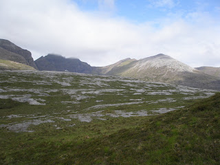
An Teallach looking good as we round Sail Liath:

Isolated Loch na Sealga looking good at the back of An Teallach:

Shenavail bothy looked like it could make a cosy night's stay:


Beinn a' Chlaidheimh and the start of Gleann na Muice:

Oh-oh, another river to cross in Gleann na Muice:

Paul showing how it's done:

My wrong-hill pointing 1, this one to Beinn Tarsuinn:

Someone had got an earlier start than us:

Running out of path at the head of Gleann na Muice:

Wrong-hill pointing 2, although this is actually the
far-back of A' Mhaighdean:


Good views of Beinn Tarsuinn as we gain height on the
back of Ruadh Stac Mor:


Taking a break from the hard work:

It's the right hill! Finally approaching Ruadh Stac Mor:

Superb views from Ruadh Stac Mor NE toward An Teallach:


A harsh boulder route to the col between today's stars:

Looking back up as Paul negotiates the boulders:


Some impressive rocks on Ruadh Stac Mor down at the col:


Looking on to easier progress up A' Mhaighdean:

Looking back to the weighty Ruadh Stac Mor:

Feeling good on arguably the most remote Munro:

A long way down, from the edge to Lochan Fada


The full panorama from A' Mhaighdean:


Dubh Loch and Fionn Loch toward Poolewe:

The full panorama from A' Mhaighdean:
Impressive crags on A' Mhaighdean:


As we descended toward Fuar Loch Mor, the clouds closed in above:

An impressive size for its height, Fuar Loch Mor:

At our furthest point, the insult of another river crossing at Lochan Feith Mhic'-illean:
He's wet now, Paul makes a damage-assessment:


A long way down Gleann na Muice Beag back to Gleann
na Muice, but thankfully on a great path:

Labels: A' Mhaighdean, Dundonnell and Fisherfield Hills, hiking, munro, Paul P, Ruadh Stac Mor
posted by George at 21:24
![]()
![]()


0 Comments:
Post a Comment
<< Home