The Crianlarich Hills: Cruach Ardrain (87) and Beinn Tulaichean (220)
Walk date: 17/08/08
My Munro #'s: 162 and 163
Pronunciations - translations - heights:
Kroo-ach ar-dran - stack of the high peaks - 1046m


My Munro #'s: 162 and 163
Pronunciations - translations - heights:
Kroo-ach ar-dran - stack of the high peaks - 1046m
Byn too-lach-an - hill of the hillocks - 946m
Statistics:
Duration - 10:50 - 16:50
Distance - 16.7km
Total ascent - 1305m
Weather - drizzle early on, drying off before returning. End of day came nice and warm.
Team - solo.
Other hikers: many.
Statistics:
Duration - 10:50 - 16:50
Distance - 16.7km
Total ascent - 1305m
Weather - drizzle early on, drying off before returning. End of day came nice and warm.
Team - solo.
Other hikers: many.
The northern end of Cruach Ardrain offers a nice walk up:


Despite a work-party the night before and only six hours of sleep I somehow managed to get up and drive back to Crianlarich to visit my last pair from these hills, Cruach Ardrain and Beinn Tulaichean.
As only light drizzle greeted me I declined the waterproof trousers and made my way along the good farm track and then the branch off to cross the River Falloch and the climb along a thin path up the grass slopes toward Grey Height where paths coming through the forest join on. Here the trousers would have come in handy as the grass was extremely wet and walking through this left my legs soaked! No matter, I decided all that I needed to do was up the pace to warm myself up and so I made great progress along the northern ridge of Cruach Ardrain, which makes for very pleasant walking, being thin enough for great views all around but wide enough to be strolling terrain.
After a small drop in height the remaining 200m or so needs to be climbed. Having seen nothing else I ended up on a path that skirted the western side of Cruach Ardrain and that meant I had to walk a way along its flat top to actually reach the summit. I know that there is a more direct path as I later saw people coming down it, but my way worked too!
The route down to the col was very straightforward on the good path and as there was then only 120m to climb before I knew it I was up on Beinn Tulaichean. Once again there was nothing but cloud on the hill so I returned to the col for a good lunch with some fine views, which then included the summit behind me!
One advantage of my alternative path up Cruach Ardrain was then that I could use it for a more direct return, which I did as the sun came out giving fine views and a nice end to the Crianlarich Hills.
A better footbridge than Ben More starts us off:

A good incline beside the forest is rewarded with fine views:

Even better on Grey Height north to Crianlarich and Tyndrum:

And east down into Coire Ardrain:

Approaching the cloud on Cruach Ardrain:

At the end of the flat top is a welcomed cairn:

From the corrie before Beinn Tulaichean to the SW:

The more diminutive Beinn Tulaichean has a cairn to match:

Stob Garbh from the corrie; not an easy link to Cruach Ardrain:

Looking back to see Beinn Tulaichean just about cloud-free:

Another good view SW: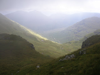

Grey height again but it really was a decent view!

Labels: Beinn Tulaichean, Crianlarich Hills, Cruach Ardrain, hiking, munro
posted by George at 21:30
![]()
![]()


3 Comments:
Hiya!
Just have found your blog and it's amazing!
I'm crazy for hiking as well, however have a definately less experience.
Is there any chance I can join your team sometimes? :)
Regards,
K
The area of Minnesota in which I live was settled by Europeans just a little over 100 years ago, and the native inhabitants before them, aside from a non-descript burial mound here and there, left no permanent monuments or structures.
I’m endlessly fascinated by the old bridges, ruins, and cairns photographed in your posts and always wonder “how old is that?” and “who built it?” etc. Certainly the bridge in this post isn’t very old, but some of the others that I’ve seen here are– wow. Very cool. Thanks for another great report!
BTW, I agree with Kornelia – I’d like to join you team, too! ;-)
Eric, in bygone days some people made a living from a lot of what is now Scotland's wilderness in various settlements and crofts. After the Jackobite revolt some 300 years ago, us English along with the wealthy landowners forced these people out to disperse the rebellious elements and make way for profitable sheep farming. There are lots of marks on the landscape from the settlements before this time, but also some way, way back as would be expected. Due to the harsh landscape things like bridges don't last long so most of these have been built by the estates and are maintained by them, and the cairns are generally just made by hillwalkers and added to over the years; on terrain that is difficult to navigate I've seeded a few cairns myself!
Kornelia, the hills are alive and should be experienced. The best way to get started with them is to join one of Aberdeen's numerous hiking clubs. There's the Granite City Hillwalkers, the Aberdeen Mountaineering Club and the Cairngorm Society to name but a few, all are friendly and open to newcomers. Have fun!!
Post a Comment
<< Home