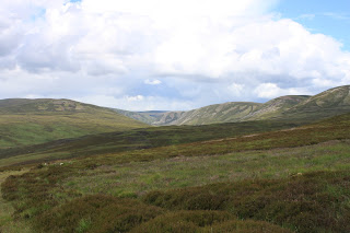
The Tarf and Tilt Hills: Beinn Dearg (124)
Walk date: 13/07/09
My Munro #'s: 187
Pronunciations - translations - heights:
Byn jerrack - red hill - 1008m
Statistics:
Duration - 12:00 - 18:00
Distance - 30km
Total ascent - 1120m
Weather - warm and close but with a heavy downpour
Team - with Steve W
Other hikers: 3


My Munro #'s: 187
Pronunciations - translations - heights:
Byn jerrack - red hill - 1008m
Statistics:
Duration - 12:00 - 18:00
Distance - 30km
Total ascent - 1120m
Weather - warm and close but with a heavy downpour
Team - with Steve W
Other hikers: 3


Having an Aberdeen bank holiday could only mean getting a Munro in, and I decided to finally use the new bike I bought last year and head for Beinn Dearg, a rather remote hill. Steve W, having this as one of his 30-something remaining Munros was also up for the long ride in.
Setting off from Old Blair we cycled briefly along a country lane before the route takes to a old track called the Minigaig, an ancient 48km route over to Kingussie. This track rises steeply here through forest and, especially in the close heat, it quickly reduced me to pushing my new stead.
As the forest ends and heathery moorland takes over the track flattens a little but to someone unaccustomed to cycling its shallow rising still proved quite tiring, although it made me keenly look forward to the return leg.
After a few kilometres the track flattens, becomes sandy and the pace is improved. From here the first views of Beinn Dearg's distant red peak are also obtained.
As the track started to descend toward the bothy we ditched the bikes and pressed on by foot, stopping briefly to lunch in the shelter and read some entries in the logbook, including some intriguing accounts of mid-winter visits.
After the bothy the track finally starts on Beinn Dearg itself. Care must be taken not to cross the river and rise to the right, but instead keep to the left and its zig-zags up toward the target. The right hand route appears to be a new deerstalkers track which did NOT appear on my 2004 1:25,000 OS map.
The going itself is very easy although it was made more interesting to us as we finally got caught in one of the heavy downpours we'd been until then successfully avoiding. This stayed with us until we were back down at the bothy but it didn't spoil the rocky summit, which I found much more characterful than expected from photos I'd seen. We did however abandon a plan to descend further up the valley allowing us to walk past Bruar Lodge; we started on it but found that it was to involve a lot of boulder-walking which we didn't fancy in the damp weather.
Once back at the bikes the real highlight of the day was experienced as the 90 minute plus ascent became a sub-30 minute breeze in which I thoroughly tested the tyres and brakes of my new bike. Superb, exhilarating stuff!
First views of Beinn Dearg:

Labels: Beinn Dearg, hiking, munro, Steve W, Tarf, Tilt Hills


