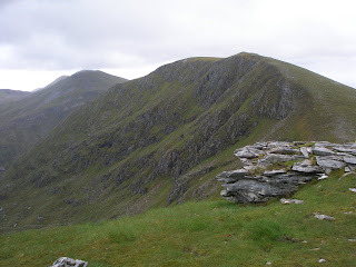
Monday, July 18, 2011

Fannaichs and Ullapool Hills: Seanna Bhraigh (262), Eididh nan Clach Geala (257), Meall nan Ceapraichean (177), Cona' Mheall (176)and Beinn Dearg (57)


Walk date: 26/06/11
My Munro #'s:
207, 208, 209, 210 and 211


Pronunciations - translations - heights:
Shena vry - old upper part - 927mAydyee nan klach gyala - web of the white stones - 927mMyowl nan kyapreechan - a rounded hilltop - 977mKonival - hill of the joining - 978m
Beinn Dearg - red hill - 1084m

Statistics:
Duration - 09:05 - 20:45
Distance - 39.2km
Total ascent - 2500m
Weather - wet from the very start with low cloud, a break on Seanna Bhraigh
Team - with Paul P
Other hikers: a plucky 2


Paul P and George 'Daddy Team' Hiking Trip 2011

Day 2 - Sunday a.k.a. 'Superbig'


Now I've always had a penchant for looking at adjacent walks in books and thinking, 'Hmm, those could go together', but sometimes this enthusiasm can go too far. As I sat plotting a route linking the two walks that could produce this 5-munro almost 40km day I thought to myself that this one was definitely too ambitious but that it would be OK because Paul would make me see sense.

Paul didn't.

Paul was in fact as enthusiastic as me, or at least, we agreed to set off and see how we got on, which is always our speak for 'We're going to do it aren't we?'. This was no exception.

While still at the car park the rain came on; I actually prefer this as it means I put on the wet gear from the start and don't have to stop later. Well, I certainly didn't have to stop to take it off at any point!!

The route sets off very gentle, meandering through a forest plantation before rising sharply on a good path as the forest peters out. The path takes you onto the vast plateau of Inverlael Forest where the good path continues across this exposed land before finally turning a corner and climbing just south of Meall Glac an Ruighe toward Meall Choire Ghlais.

When the ground flattens the route becomes ambiguous and there are many options of how to make your way across the scarred land to Gate of Ca'-derg and its majestic views. The going is a lot slower than you might think due to having to walk round many a sudden drop.

From the gate the route on to Seanna Bhraigh is simple and the deep corrie is a just reward. Although this was our only view of the day, it did make the whole thing worthwhile. When we were leaving the summit we met our only other 2 hikers of the day, one looking much more enthusiastic than the other. The enthusiastic one informed us that they were doing the same loop but descending a different and quicker way, so we could meet them at their car later if we wanted. Hmm, they seemed nice guys but I don't want to have my down route dictated by someone who might or might not be there at the end of a full day's hiking. We said that we would see about it, but then we never saw them again, so caution seemed to have been the best course of action!

Anyway, to move on the only option is to slowly retrace your steps to Meall Choire Ghlais and then make your best line up the rocky slopes of Eididh nan Clach Geala. The link to this hill is by no means obvious, but is written into many books.

After that, steep grass and rocks take you over Meall nan Ceapraichean to Bealach an Lochain Uaine which was tough going for supposedly flat ground, and not just a little confusing in the thick mist.

We ascended first up Cona Mheall which was decent enough before returning and taking on the huge bulk of Beinn Dearg. At this point we were both fairly done in, and I was certainly slipping all over the path just because of not lifting my legs enough with each step. Eventually though, the path crosses the boundary wall and the incline lessens, becoming a rocky crest with a large summit cairn. Here we rewarded ourselves with a second lunch (it was 5ish) and a sit down!

Fortunately, the descent proved very swift. We were soon off Dearg and on a fantastic path along Coire Mathair Lathall which we pounded along back down to the forest plantation, arriving just under 12 hours after starting out. Time for a proper meal and a beer or two!

Crossing rivers on the Inverlael Forest plateau:


The view from Seanna Bhraigh:

And another:

Gate of Ca'-derg:


Taking a stroll:

T'was wet and miserable for some long stretches!This was approaching Meall nan Ceapraichean:

Labels: , , , , , , , ,

The Fannaichs and Ullapool Hills: Am Faochagach (210)


Walk date: 25/06/11
My Munro #'s: 206


Pronunciations - translations - heights:
Am foechakack - place of the shells - 954m


Statistics:
Duration - 13:15 - 17:45
Distance - 15.8km
Total ascent - 1005m
Weather - some light rain once at height and very windy on the top, but generally fine and ended in warm sun.
Team - with Paul P
Other hikers: a couple

No cause for concern once the river's crossed!


Paul P and George 'Daddy Team' Hiking Trip 2011

Day 1 - Saturday

Yes, despite both being Dads now, Paul and I still somehow managed to make it away hiking this year, although clearly time for the write-ups has since been lacking!

This year we opted to go to the very far north, stopping in locations as remote as Aultguise bunkhouse, Achininver and Tongue, and taking in Munros whose names conjure a certain mystique such as Seanna Bhraigh, Ben More Assynt and Ben Hope.

First up was Am Faochagach which is an isolated peak famed for it's often impossible river crossing. Fortunately Abhainn a' Gharbhrain was managable on a dry day such as this, but it was still tricky. It is a broad river, which many small slippery rocks that are just a little too far away for comfort, most of them would soon submerge with a good rain. Just to get to it means covering a wide bog land which was tough enough when it was relatively dry and our first work of the week, this is surely one to avoid if even damp out.

After the river the climbing starts at a pretty even rate over decent ground. The walking speeds up once on the long crest and it generally gives little concern while rewarding with superb views west over to Beinn Dearg and it's pals.

The only problem we had is to be overconfident leaving the summit, a little bit of cloud was all it took us to set off for a short spell down the wrong way. Ahem, compass bearings anyone?

A pint of An Teallach ale down at the Aultguise was still deserved of course...


Crossing the bog at the head of Loch Glascarnoch:

That river crossing!

Sun on the descent:

The pint!

Labels: , , , ,

Wednesday, July 02, 2008

The Fannaichs and Ullapool Hills: Beinn Laith Mhor Fannaich (209), Sgurr Mor (43), Meall Gorm (215) and An Coileachan (266)

Walk date: 20/06/08
My Munro #'s: 153, 154, 155 and 156

Pronunciations - translations - heights:
Byn leea voar fannich - big grey hill of the Fannich - 954m
Skoor more - big peak - 1110m
Myowl gorram - blue hill - 949m
An kilyachan - the little cock - 923m

Statistics:
Duration - 09:45 - 18:45
Distance - 28.9 km
Total ascent - 1795m
Weather - Cloudy with periods of strong winds on top. Periods of heavy rain and two bursts of strong stinging hail but with even dry time between showers to keep you happy.
Team - solo.
Other hikers: 2.


Although not advertised, the northern approach is fine:


Paul P and George Ullapool Hills 2008 - Day 7 (Fri)

After the previous day's epic, and with the prospect of a 4-Munro day ahead, Paul decided to play a cautious hand on this day and stay in Ullapool to rest his knee and ankles. Thus, I set out from an exposed car park on the A835 and started looking for the path up alongside Allt a' Mhadaidh. My book had actually recommended a start from Loch Fannaich which would have required a 8km bike ride up a private road but after the day on Meall a' Chrasgaidh/Sgurr nan Clach Geala/Sgurr nan Each I had eyed this alternative route in from the north and in any case favoured any route now that didn't include the use of a bike!

Predictably I was immediately faced with a river crossing, this time of the shallow but slimy variety. This crossing led to another river but remarkably one with a bridge attached. After crossing this one the path was good and obvious and rose to meet a hydro power station track which had come up from the end of Loch Droma.

I stayed on this track until its end where a path then continues in the same line and presents yet another river crossing, this time with a comedy cairn on the far side. Without too much trouble I got across but soon had to leave the path as it was clearly continuing straight to Loch a' Mhadaidh while I needed to make a break for the slopes of Beinn Laith Mhor Fannaich. Once on its slopes the familiar slow rise on rough and rocky ground began but was rewarded with grand views below.

Once on top the wind immediately made its presence known and made normal walking difficult. After touching the summit I quickly dropped SW to the col for some protection and set myself up for more with some refreshments. It was fortunately I had taken that opportunity as within minutes a strong hailstorm came in from behind Sgurr Mor and made things truly unpleasant, even turning my thoughts to a retreat once I'd taken in this second hill.

This was a day of changeable weather however, and as soon as I started climbing on Sgurr Mor the sun came out again making for a very enjoyable visit to this tall peak being an excellent vantage point to its fine neighbouring hills.

From Sgurr Mor easy walking takes you to the shallow crest of Meall Gorm and then down and up onto the back of An Coilleachan, which offers superb views of Loch Fannaich and the rest of the ridge down to it. This would be a fine route onto these hills but for me it was a slope too far and after taking in the grandeur of the location I set about re-tracing my many steps back. A great set of hills that offers a fairly easy day out once the work of the initial ascent has been done.


Well, may as well start the day with a river crossing hey?

But only one to start with as some nutter has built a bridge!

A subtle cairn marks the branch between the Hydro road and the path:

You know you're going to have to cross this Allt a' Mhadaidh:


No betting on a path up onto Beinn Laith Mhor Fannaich:

Views north from the grassy back of Beinn Laith Mhor Fannaich:

Loch a' Mhadaidh just making an appearance to the NW:

The onward route to tall fella Sgurr Mor:

Looking back to Beinn Laith Mhor Fannaich:

Now that's what I call a shelter!

Serious drops off Sgurr Mor:

And then some:

A fine cairn for the fine hill of Sgurr Mor:

Over to Sgurr nan Clach Geala and Sgurr nan Each:

Down to Beinn Laith Mhor Fannaich:

And the onward route south with Loch Li and Loch Fannaich in view:
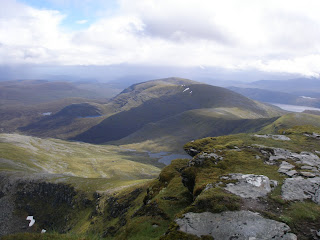
Looking back to Sgurr Mor:

Loch an Fhuar Thuill Mhoir and Loch Li:


Onward to Meall Gorm:

And finally to An Coilleachan:

A good cairn marks the day's furthest point:

Looking all the way back north:

Tempting lush slopes continue on down to Loch Fannaich:

The remote western end of Loch Fannaich:


With Slioch just visible in the distance:

And now with the full panorama:

A tombstone on An Coilleachan reminds us of potential dangers:

An example of some fine Scottish weather as I returned to Sgurr Mor!


Snow and cloud close the day:

A helpful summit-avoiding path on Beinn
Laith Mhor Fannaich:

Another grand Ullapool evening:

Labels: , , , , , , ,

The Fannaichs and Ullapool Hills: Sgurr Breac (138) and A' Chailleach (144)

Walk date: 18/06/08
My Munro #'s: 151 and 152

Pronunciations - translations - heights:
Skoor brechk - speckled peak - 999m
A chalyach - the old woman - 997m

Statistics:
Duration - 10:00 - 16:30
Distance - 19 km
Total ascent - 1180m
Weather - Cloudy and very windy at altitude early in the day. Wet for a while but with a sunny finish.
Team - with Paul.
Other hikers: 1.


Completing the circuit:


Paul P and George Ullapool Hills 2008 - Day 5 (Weds)

The second of our 'recovery days' saw us returning to the previous day's glen and taking in the rest of the grand circuit. Knowing the ascent well, we travelled up the glen without incident, with myself adding some more to Gibb's Bridge and Paul refusing its offering again!

After refreshments at the col in a fine shelter, we rose steadily up the back of Sgurr Breac and onto its broad summit crest despite some impressive gusts of wind slowing us down. After the summit we kept with the good but faded in places path onto Toman Coinnich and then up A' Chailleach, which in nice weather must be a gorgeous hill but one we experience in heavy rain and continued wind. By the time we were back at Toman Coinnich it was of course sunny again, and this gave some great weather effects as the cloud slowly dissipated.

For a descent, we went north with good walking down Druim Reidh (a path also appeared to go down this having originated from Bealach Toll an Leachall, but we had missed its start in the poor weather). The path also remained good down Sron na Leitir Fhearna which we were very grateful for as it seemed imposingly steep from below it. A straightforward stomp to the car then followed and without any more 'manual' river crossings!


An old friend, revisiting Gibb's Bridge:

Gaining height in the return to the col:

Let's do it, the back of Sgurr Breac:

Paul demonstrates just how windy it was getting:

I can see the car from here, and the east end of Loch a' Bhraoin:

A small mound of a cairn survives on Sgurr Breac.
Loch Fannaich behind:


And in motion:


From Toman Coinnich onward to A' Chailleach:


Looking back to Sgurr Breac:

Loch Toll an Lochain from the approach to A' Chailleach:

A happy man and his A' Chailleach cairn:

Cloud burn-off back at Toman Coinnich:

Ditto:

And with a Paul to boot:

Good walking down the back of Druim Reidh:

These lower slopes still provided good views:


A' Chailleach and Paul:

Loch a' Bhraoin looking good:

As Druim Reidh runs out, some quick descent is required:

Labels: , , , , , ,