Tuesday, January 13, 2015

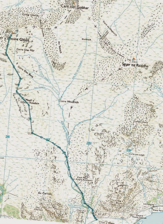
Glen Affric and Strathfarrar: Sgurr a' Choire Ghlais (60) [and Carn nan Ghobhar (153) and Sgurr na Ruaidhe (151)]

Walk date: 11/7/14
My Munro #'s: 257

Pronunciations - translations - heights:

Skoor a chor a ghlash - peak of the greenish-grey corrie - 1083m

Statistics:
Duration - 11:10 - 17:05
Distance -  17.5 km
Total ascent -  1337m
Weather - Hot day but breezy on top and a little cloudy for a while.
Team - with Paul P
Other hikers: 6 others (1 topless!)


Day 7 - Friday


Today was our furthest trip away from our base as we travelled north to Strathfarrar, a glen I had already been in twice, once two years ago on a day that Paul sat out due to injury, and once the year before with Paul, but in each case in awful weather and with grateful, beaten retreats.

Today was different, today was simply gorgeous!  Sun, minimal wind, clear views.  This was sublime hiking.  However, due to my problematic toes, I only targeted the Munro I hadn't visited, Sgurr a' Choire Ghlais, but I had given Paul the choice of continuing on to Carn nan Ghobhar and Sgurr na Ruaidhe which were the ones he had missed on his sit-out day as I battled with thick snow and gales!  

Due to the great weather today, I decided to stay in my Merrells and see how they faired.  They faired amazing!  The pain was suddenly minimal as feet my were cushioned in a flexing shell, and I sprang along on the soft ground.  Such was the improvement that after summiting on Sgurr a' Choire Ghlais and looking lazily over at the rest of the circuit in superb clarity I declared to Paul that I was sticking with him on the full tour.

Onwards we strode up onto the rocky plain of Carn nan Ghobhar which had been horrible to struggle over in ice, but today the worst it could throw at us was a topless (male) hiker.  From there Sgurr na Ruaidhe  came pretty easy, and then even the descent couldn't dent my enthusiasm.  Marvellous stuff, especially the pint and burger at the Struy Inn afterwards - I just wish I had tried the Merrells earlier!


The start of the day.  Glorious, glorious, sun:
Coming up on Sgurr a' Choire Ghlais:


On top of Sgurr a' Choire Ghlais:


Views from the two additional hills!


Labels: , , , , , , ,

Sunday, June 23, 2013

Glen Affric and Strathfarrar: Sgurr Fhuar-thuill (82) but NOT Sgurr a' Choire Ghlais (60)

Walk date: 14/04/13

My Munro #'s: 236

Pronunciations - translations - heights:

Skoor ooar hil - peak of the cold hollow - 1049m
Statistics:
Duration - 10:00 - 14:30
Distance -  10.8km
Total ascent -  1045m
Weather - calm in morning, hint of sun and blue sky, very windy along top ridge.  Heavy rain at the end of the day.
Team - with Paul P
Other hikers: none


Loch Toll a' Mhuic:
With a forecast of winds upto 100mph in the afternoon, there was considerable discussion with the team at home regarding whether or not anything at all should be attempted on this day, but with the forecast also predicting a 'lull' in the morning, we decided to reduce our aims and just try the one hill which would mean minimal time up at height and maximum protection against the wind.

And so, after a tremendous breakfast at the Struy Inn, we drove up lonely Strathfarrar and set off on a good Landrover track over the lower slopes, soon gaining reasonable height.  The river beside the track was immediately a torrent, and the waterfalls marked on the map were very impressive.  

Above the waterfalls was a small bridge which would have been used on the way down if we had still been going for the circuit, but that will be for another time.

After that the path becomes more winding, but also flattens out and progress was good.  However, just below the loch in the corrie the path hits a river but there was no crossing possible with the depth of the flow going through.

In soggy conditions then we had a last ditch effort to round the loch just in case it was possible, but fully expecting to have to turn back. Fortunately the far side was quite manageable, and we were soon back on the path entering the high corrie below Sgurr na Fearstaig and treading over thick patches if snow.

With cornices above, Paul spotted a diagonal line of snow moving NE which indeed turned into the route onward, helpfully confirmed later on by snowy footprints.  This route was hard going, with a deep snow ascent being replaced by a slippery traverse on all fours.

Eventually, we made it onto the broad ridge, with less than 500m to the summit.  Here the winds were strong but manageable, I would guess being 50-60 with gusts of 70mph.  A quick tap of the cairn then and we were retracing our steps.

As predicted, as soon as we were off the ridge, we weren't really affected by the wind, and soon we were making a decent quick descent in the increasing rain, looking forward to a dry car, a late lunch, and an eventual dinner in Pitlochry at The Moulin Inn.  

The shortened day means Sgurr a' Choire Ghlais is the only hill in the whole district that hasn't received my attention, but somehow I'll cope with having to stay at the Struy Inn again, and it's always better safe than sorry!


That tricky traverse on the way down:

Looking south with Sgurr na Muice on the right:

Me 'enjoying' the traverse:

Making good progress once down:

The diagonal of the traverse visible on the slope:

The Moulin!

Labels: , , , , ,

Sunday, August 19, 2012

Glen Affric and Strathfarrar: Sgurr na Ruaidhe (151) and Carn nan Ghobhar (153)

Walk date: 30/04/12
My Munro #'s: 221 and 222

Pronunciations - translations - heights:
Skoor na rooy - peak of redness - 993m
Kaarn nan gower - hill of the goats - 992m

Statistics:
Duration - 10:00 - 16:15
Distance - 21.7 km
Total ascent - 1200m
Weather - damp and misty, windy with hail and snow at height
Team - solo
Other hikers: none


Paul P and George 'Daddy Team' Hiking Trip 2012
Day 2 - MondayThe second of our big days was wisely chopped down to size, in fact for Paul it didn't happen at all as he opted to sit today out to ensure his various niggles from the terrible Loch Mullardoch experience the day before didn't end up finishing his entire week early for him.  For me, despite a battered ankle I decided to press on, although I prepared myself for abandoning the full plan if problems did indeed arise.There was almost one to start with as the turn for Strathfarrar is completely unmarked, however I did make it for the gate opening at 09:00 and drove up the private track to the power station marked.  After the glorious weather the day before, this was a dull day with a heavy sky, as if the weather had changed to match the mood and fitness levels!  I could have parked closer to the walk and wished that I had, as the short patch of road on a bashed ankle was extremely unforgiving.  Nonetheless, I was soon on the track and gaining height, and in my hobbling way I progressed steadily.Unfortunately the cloud seemed to hang just below the snow line and so I was soon faced with the disorientation of white sky and white ground and for good lengths of time I made my way over icy slabs with no definition whatsoever.  As the height increased so did the wind and I was soon blasted with horizontal hail and snow.  With my GPS and compass firmly gripped I finally made it onto Sgurr na Ruaidhe and moved off immediately toward Carn nan Gobhar.  After this hill I dropped a little too quickly and had to traverse soft snow for some distance.  I was very glad to hit the crest again.  Although the weather was being fierce my progress was actually good, and I was toying with myself of going for the three or even the four instead of just the first two as I'd been telling myself on the way up.  However, this internal debate came to a head as I tried to make my way across to Sgurr a' Choire Ghlais; I came to a point where my way on was a convex slope of pure white with some distant black jagged rocks.  The slope disappeared out of sight and the scale could not be made out.  This situation like a switch hit my personal safety alarm and the decision was made; I was turning south and escaping off An Socach for home.  There is always another day.


One of the only photos, I carried the weight of the camera for nothing on this day!

Labels: , , , , , ,

Monday, May 14, 2007

Glen Affric and Strathfarrar: Beinn Fhada (Ben Attow) (100) and A' Ghlas-bheinn (273)

Walk date: 12/05/07
My Munro #'s: 127 and 128

Pronunciations - translations - heights:
Byn ata - long hill - 1032m
A glash vin - the greenish/grey hill - 918m

Statistics:
Duration - 09:00-16:45
Distance - 26.5km
Total ascent - 1543m
Weather - warm at start, but then the cloud closed and brought rain. Wet from bealach on return.
Team - solo
Other hikers: many


Cut back to a sane walk, the reduced day in red:


Hiking Expedition '07 - Glen Shiel area - Day 8 (Sat 12th)

Despite insanely ambitious original plans to add Sgurr nan Ceathreamhnan and Mullach na Dheiragain onto this day, I thankfully downsized my aims to this happening duo instead, which was a good thing considering that they took me almost eight hours on their own! Things weren't helped by the fact that I had parked at the mountain rescue post by the campsite in Morvich when it later turned out I could have parked down the non-private private road at Dorusduain, which would have saved a fair amount of time!


A little friend I had whilst booting-up:


Anyway, a good path leads on from the road passing the campsite when it finally stops, and this path slowly rounds Beinn Bhuidhe to reach the ascent of Beinn Fhada an hour or so later. The good path continues up onto the north side of Beinn Fhada, which is tough work, but nothing unexpected. Once up, make sure you head southeasterly to the summit and don't follow the edge around west, as the summit you can see is Meall an Fhuarain Mhoir and not the desired target of Attow.


The second target is first seen, A' Ghlas-bheinn:


The steep gully to Bealach an Sgairne:


The wide corrie of Ben Attow, Coire an Sgairne:


A busy summit. Other hikers? Pah!


With a busy summit I soon moved off back down the path and prepared myself for taking on A' Ghlas-bheinn and its intimidating southern slopes. There was no need for worry however as once the path is followed to the very head of Bealach an Sgairne, a wide cairn marks a very good and easy path taking on the ascent along the eastern edge of this chunky beast.


The steep southern side of A' Ghlas-bheinn:


A Munro for another day, Sgurr nan Ceathreamhnan:


The superbly tranquil Loch a' Bhealaich:


Straight-forward plodding gets you to the top and unless you're up for camping or staying at Alltbeithe Youth Hostel in Glen Affric, it's pretty much time to head for home. My own plotted route from here, and one that most books recommend, was to decend off A' Ghlas-bheinn down the western slopes into Dorusdain Wood. This I started as the map above shows, but rough grass and bog got me to thinking that it was going to be quite hard work on my tired legs, and so I had a change of heart and made my way back to the good path I was well-acquainted with. I then just had to keep on it and do the work to slowly get back to the car, accompanied as I did by the gentle plodding rain I'd seen coming in from Skye whilst on top.


Morvich and across to Ratagan from A' Ghlas-bheinn:


In sight, the summit of A' Ghlas-bheinn:

The panoramic view from A' Ghlas-bheinn:


Heavy weather coming in from Skye, time to get wet:

For my last night, an amazing sunset from Ratagan:

The Five Sisters looking good in the fiery evening light:

Labels: , , , , , , , ,