Monday, August 18, 2008

The Crianlarich Hills: Cruach Ardrain (87) and Beinn Tulaichean (220)

Walk date: 17/08/08
My Munro #'s: 162 and 163

Pronunciations - translations - heights:
Kroo-ach ar-dran - stack of the high peaks - 1046m
Byn too-lach-an - hill of the hillocks - 946m

Statistics:
Duration - 10:50 - 16:50
Distance - 16.7km
Total ascent - 1305m
Weather - drizzle early on, drying off before returning. End of day came nice and warm.
Team - solo.
Other hikers: many.


The northern end of Cruach Ardrain offers a nice walk up:


Despite a work-party the night before and only six hours of sleep I somehow managed to get up and drive back to Crianlarich to visit my last pair from these hills, Cruach Ardrain and Beinn Tulaichean.

As only light drizzle greeted me I declined the waterproof trousers and made my way along the good farm track and then the branch off to cross the River Falloch and the climb along a thin path up the grass slopes toward Grey Height where paths coming through the forest join on. Here the trousers would have come in handy as the grass was extremely wet and walking through this left my legs soaked! No matter, I decided all that I needed to do was up the pace to warm myself up and so I made great progress along the northern ridge of Cruach Ardrain, which makes for very pleasant walking, being thin enough for great views all around but wide enough to be strolling terrain.

After a small drop in height the remaining 200m or so needs to be climbed. Having seen nothing else I ended up on a path that skirted the western side of Cruach Ardrain and that meant I had to walk a way along its flat top to actually reach the summit. I know that there is a more direct path as I later saw people coming down it, but my way worked too!

The route down to the col was very straightforward on the good path and as there was then only 120m to climb before I knew it I was up on Beinn Tulaichean. Once again there was nothing but cloud on the hill so I returned to the col for a good lunch with some fine views, which then included the summit behind me!

One advantage of my alternative path up Cruach Ardrain was then that I could use it for a more direct return, which I did as the sun came out giving fine views and a nice end to the Crianlarich Hills.


A better footbridge than Ben More starts us off:


A good incline beside the forest is rewarded with fine views:

Even better on Grey Height north to Crianlarich and Tyndrum:

And east down into Coire Ardrain:

Approaching the cloud on Cruach Ardrain:

At the end of the flat top is a welcomed cairn:

From the corrie before Beinn Tulaichean to the SW:

The more diminutive Beinn Tulaichean has a cairn to match:

Stob Garbh from the corrie; not an easy link to Cruach Ardrain:

Looking back to see Beinn Tulaichean just about cloud-free:

Another good view SW:
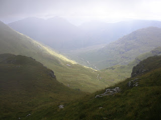
Grey height again but it really was a decent view!

Labels: , , , ,

Monday, July 28, 2008

The Crianlarich Hills: Ben More (16) and Stob Binnein (18)

Walk date: 21/06/08
My Munro #'s: 160 and 161

Pronunciations - translations - heights:
Byn Moar - big hill - 1174m
Stop binyan - hill of the anvil - 1165m

Statistics:
Duration - 11:10 - 16:40
Distance - 12.7 km
Total ascent - 1570m
Weather - Extremely muggy. Very warm indeed but cloud never burned off. Midge heaven!
Team - solo.
Other hikers: many.


An alternative descent gave me some variety:


In possession of a shiny new car and with Sonia committed to work on the Saturday, I just couldn't help driving the near 3 hours to Crianlarich and finally taking in the mighty Ben More and its almost-as-high neighbour Stob Binnein. I had to be quick about it however as we had dinner plans back in Aberdeen, and so this was set up as an enjoyable stomp of a day out.

The worst part of this walk is that there is no car park at the start of the route, which means you have to spend 10 minutes or so walking at the edge of a fast main road. Once this is over, a sign leads to around the yard of Benmore Farm onto a farm track that zig-zags gently up the lower slopes. Don't get used to this as after a gate the track remains flat and heads south while Ben More stands imposingly above. Continue south on the track for a short distance and you start to see several little trails heading on up. I took one of these early on and carried on as I climbed to see the odd sign of someone else having done the same thing. Eventually however I came upon a path more to the north-western flank and this offered slighty faster progress.

This climb up is a serious feat, rising as it does from 160m to the summit at 1174m with little variety in the gradient. Although I was determined to do it as fast as I could I still needed a couple of water breaks and the sweat was dripping off me. Nothing lasts forever though and with persistence, two hours after leaving the car, I found myself enjoying the rounded summit. Unfortunately, despite the summit being cloud-free by about 10m, the rest of the visible world comprised swirling white mist and photo opportunities were few.

After the climb up it was a strange feeling to be descending, but fortunately it wasn't for long as Bealach eadar-dha Bheinn is still very high at 860m. The climb to Stob Binnein, although requiring work, was by comparison to the start of the day, hardly noticeable. Still deep in cloud and with the cairn covered in midges I didn't hang about but returned to the bealach for lunch.

With no views likely on a return up Ben More I decided to check out a path leading off the bealach west toward Benmore Burn as a descent route instead. This thin but good path allowed fast progress but in places was indistinguishable from bog and I wondered how hard it would be to stick to on an ascent; indeed I would recommend accepting the honest slog up Ben More's front instead. However as a descent this path worked fine and it took me down to the farm track again, albeit at its highest point, but I stuck with it to return to the road and enjoyed seeing the 'bridge' that's there on the map, an illustration of how maps cannot always be trusted (see last photo)! With a book time of 6-8 hours, I didn't feel too bad at 4.5, and I still think I could have managed 4 if it wasn't so hot!


I'm sure it looks good when there's no cloud!
On the good path on Ben More into the cloud!

Getting rocky near to the top:

How dare people be up there before me?

I set up this pic from the trig point, t'was a little cloudy!

Briefly, a view to the route on south:

The summit of Stob Binnein at 1165m, still covered in midges!

Some teasing cloud breaks back toward the bealach:

Almost seeing the summit of Ben More from the bealach:

South up Benmore Glen from my descent:

Benmore Glen forest and the farm track:

The bridge at the top of the farm track has seen better days!

Labels: , , , ,

Sunday, February 18, 2007

The Crianlarich Hills: Beinn Chabhair (244)

Walk date: 17/02/07
My Munro #'s: 99

Pronunciations - translations - heights:
Byn chav-aar - hill of the hawk - 933m

Statistics:
Duration - 11:00 - 17:45
Distance - 13km
Weather - dry with cloud at start, some clear sky. Moderately heavy snowfall near summit turning to broken cloud with fantastic sunlight on descent.
Team - with Sonia

A certain amount of free-styling on the upper slopes:
With daylight now extending to six in the evening and the sun even coming up before noon, it was deemed an appropriate time to take in the first Munro of 2007. I must apologise before we get under way for the lack of pictures, as having got out of the routine I forgot my camera! However, the Sonia remembered her film-camera, so I shall update this post once they're developed.
A 06:45 awakening saw us successfully leave Aberdeen at 08:00 and arrive at Beinglas Farm just before 11:00, although we almost didn't after the sharpest turn off a main road I have ever experienced, which then moved straight onto a rickety wooden bridge accompanied with the unnecessary sign, 'One vehicle at a time'.
Moving past the nice looking camper's facilities, including the West Highland Way wigwam-type accommodation huts, the obvious path moved steeply up the left side of Ben Glas Burn for the first kilometre before flattening out into the wide upper glen, where the path becomes more indistinct and, predictably, boggy.
Rounding the south side of the impressive crags of Ben Glas, the path starts to climb again, albeit at a more gentle pace as no one choice of path takes you along to Lochan Beinn Chabhair. Some climbing is then necessary to get up onto the north-western side of Beinn Chabhair itself. We started at a gentle incline before we realised a more direct approach was needed and climbed up steep grassy slopes freestyle to get to the base of the the northwestern ridge. However, there is a path that starts in a gully between two buttresses of Meall nan Tarmachan that we took on the way down, and so I would recommend finding this for ease of mind.
No matter how you get there, once on the northwestern ridge it all becomes straight forward as an easy-going and distinct path takes you winding towards the summit. On this part, we found ourselves in a wonderful snow storm, with huge flakes falling in abundance all around with a reflective Loch Lomond visible to the south seemingly hung in the middle of a sky of grey. Wonderful stuff.
At the summit, we didn't hang around, but started our descent quickly getting down off the ridge to walk back across the flats in some amazing evening sun that made us so glad to have gone to all the bother of getting up and out. The one downside was the return of Sonia's feet problems, which slowed down our final descent pace considerably. Nevermind, as we'd timed it fine and had plenty of daylight to make it back in. With a huge fish supper at Comrie and then a Black Sheep before bed when we got into Aberdeen at 22:00, this was a full and fantastic day. It was great to be back in the hills. Each to their own, but how can anyone not like this??

Labels: , , , , , ,

Sunday, October 22, 2006

The Crianlarich Hills: An Caisteal (147) and Beinn a' Chroin (233)

Walk date: 21/10/06
My Munro #'s: 96 and 97

Pronunciations - translations - heights:
Aan kaistail - The Castle - 995m
Byn a chroin - Hill of Danger - 940m

Statistics:
Duration - 11:45 - 16:45
Distance - 13.9km
Weather - breaking cloud, warm in sun, rain at end of day
Team - solo

Plotted route in blue, taken route in red:


The mist clearing on Coire Andoran:


Mist remaining in the glen, over to Stob Glas:


Panoramic of the breaking cloud:


Summit of An Caisteal from the south:


Beinn a' Chroin from the slopes of An Caisteal:


All that work for some rocks!


A break in cloud reveals An Casiteal from Beinn a' Chroin:


Start of Alien anyone? Rocks through the mist:


After quite a drive from Aberdeen, which included great views of the monstrous Ben More rising through broken cloud, I parked up besides my targets of the day, but by that time with the cloud fully descended down to 200m!

Once kitted up, I made my way down the farm track and over the River Falloch on a bridge built by the R.A.F! The 'path' leaves the track on the turn before the cottage, and passing through a gate starts following the river upstream. However, this was starting to depart from my plotted route, and with height to gain I'd always rather get at it sooner than later, so I veered off ESE towards the higher flow of Allt Andoran. The terrain here was of long springy grass and often I thought I was seeing paths of previous hikers, but more likely I was seeing grass bent over due to considerable water-flow! It didn't take long to realise that looking for a path was going to be a fruitless venture, and so through the mist I just kept my line to meet the river below the slopes of Coire Andoran.

The slopes up Coire Andoran and onto the appropriately titled 'Twistin Hill' were no mean feat, and I was getting very hot as I doggedly increased my height as the first faint signs of the sun appeared through the mist above. At around 500m, all around the mist finally burnt off revealing some fantastic views both into the glen below, but also north towards the Bridge of Orchy Hills.

The persistence on the slopes finally paid off and revealed a path along Twistin Hill, which looked as if it progressed all the way down Sron Gharbh, and made me think that that would have been a fine alternative route up compared to the more ad hoc approach I had taken! Anyway, continuing the ascent the path allowed quick progress. A scary looking outcrop of rock ahead is actually quite easy, as an easy path works around it. On the path the summit is soon reached, but the cloud was in again by this time so I cannot report on the views!

Descending to the south along the obvious path, height was quickly lost over quite rocky ground. Hands are needed at a few points, but there is nothing too technical to be concerned about here, unless you're wanting to try it in snow or ice; there were a number of rocks along this route with crampon scratch marks clearly apparent!

The rise to Beinn a' Chroin starts at soon as the bealach is reached. This ascent includes the most tricky parts of the day, as might be expected when the translation is 'Hill of Danger', but again in fine weather it is nothing that a couple of moments of hand work won't sort out. Before too long, the flat top is accessed and a fine path takes you along to the official summit of 942m at the western end (388186). Again, the cloud was in here, so I imagine the views are nice!

I had plotted a return route over Stob Glass, however, the route onto it from the bealach I had plotted didn't seem to exist, and instead would have been some very unconfortable traversing along steep slopes. I instead thought I might access the ridge from the summit of An Caisteal, but then concluded that if I was returning to this hill that I may as well retrace my outward route exactly as at least then I knew what I was getting; the day had already been a bit more technical than I had imagined and was taking longer than expected, I therefore opted for the least possible amount of extra adventure!

A very quick descent of the Coire Andoran was my reward for the earlier work up it, and left me very warm. As a result I took off my coat for the quick stomp back over the grassy slopes to the farm track. Of course this was the cue for the rain to come down, but I refused to stop again and was very soggy once back at the car, ready for a change of top before the prolonged wet drive back.

Labels: , , , , ,