Achnashellach and Torridon Hills: Maol Chean-dearg (247)
Walk date: 04/05/06
My Munro #'s: 76
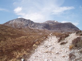
The first sign of the target, Maol Chean-dearg:
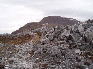
Path remaining obvious for now; the south-west ridge:
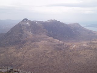
Another lost hill, ENE to Beinn Liath Mhor:
Hiking Expedition 2006! 10:15-15:00. The second of my two 'light days' proved to be heavier than expected at almost 5 hours, when my usually conservative guidebook had suggested 3-5! Granted, I was taking my time but 3 hours would be some pace!!
I set off from the car park just before Coulags (coming from Locharron) with sunburn-threatening sunshine and only light winds. The public right of way to Torridon marks the way off the road and a Pathways Trust sign encourages you to skirt a property ahead by veering off to the left beside the river. However these footpath types can't make footpaths very well and the way ahead was soon a large collection of mud. The track through the property is soon picked up after this mud and once re-united the going is good though a little wet at times. This path continues on for a surprisingly long time over the bridge, past the bothy and the old stone of Clach nan Con-Fionn, before a small cairn marks the start of the climbing to your left.
As height is increased the target becomes clearer and clearer up ahead. Ascent routes are obviously visible on the scree slopes just south of Coire Garbh, but I kept to my original plan of going up the south-west ridge. If taking this route, wait for the bealach where the paths are clearly revealed. Unfortunately, I was tempted too early and made slow progress over loose stone, only then to see the paths once the hardest work was done!
From the top of the ridge the path remains obvious for a short spell, but is soon lost amongst more loose stone and plenty of sharp rocks. For the path to the summit, keep to the left (west) of the boulder field; a tiny cairn on top of a large rock marks its start, but this is initially hidden by an annoying hump on the section just before the climb. Indeed my knowledge of the cairn is retrospective as on the way up I made a direct line up the boulder field, which to be honest is a fine route as the boulders are sturdy, only finding the actual path on the return. At the summit you are greeted with a large cairn complete with shelter sections and really spectacular views all round. For the second day in a row, the forecast bad weather only hit once I was safely in the car. Now that's the way it should be!!
My Munro #'s: 76
The first sign of the target, Maol Chean-dearg:

Path remaining obvious for now; the south-west ridge:

Another lost hill, ENE to Beinn Liath Mhor:

Hiking Expedition 2006! 10:15-15:00. The second of my two 'light days' proved to be heavier than expected at almost 5 hours, when my usually conservative guidebook had suggested 3-5! Granted, I was taking my time but 3 hours would be some pace!!
I set off from the car park just before Coulags (coming from Locharron) with sunburn-threatening sunshine and only light winds. The public right of way to Torridon marks the way off the road and a Pathways Trust sign encourages you to skirt a property ahead by veering off to the left beside the river. However these footpath types can't make footpaths very well and the way ahead was soon a large collection of mud. The track through the property is soon picked up after this mud and once re-united the going is good though a little wet at times. This path continues on for a surprisingly long time over the bridge, past the bothy and the old stone of Clach nan Con-Fionn, before a small cairn marks the start of the climbing to your left.
As height is increased the target becomes clearer and clearer up ahead. Ascent routes are obviously visible on the scree slopes just south of Coire Garbh, but I kept to my original plan of going up the south-west ridge. If taking this route, wait for the bealach where the paths are clearly revealed. Unfortunately, I was tempted too early and made slow progress over loose stone, only then to see the paths once the hardest work was done!
From the top of the ridge the path remains obvious for a short spell, but is soon lost amongst more loose stone and plenty of sharp rocks. For the path to the summit, keep to the left (west) of the boulder field; a tiny cairn on top of a large rock marks its start, but this is initially hidden by an annoying hump on the section just before the climb. Indeed my knowledge of the cairn is retrospective as on the way up I made a direct line up the boulder field, which to be honest is a fine route as the boulders are sturdy, only finding the actual path on the return. At the summit you are greeted with a large cairn complete with shelter sections and really spectacular views all round. For the second day in a row, the forecast bad weather only hit once I was safely in the car. Now that's the way it should be!!
Labels: Achnashellach, Maol Chean-dearg, mountain, munro, Torridon, Torridon Hills
posted by George at 16:39
![]()
![]()


0 Comments:
Post a Comment
<< Home